


AQUACYCLE completes online Irrigation Suggestion Tool
An online Irrigation Suggestion Tool to assist in the drawing up of optimal action plans for the reuse of treated wastewater brings yet another legacy of the ENI CBC Med funded AQUACYCLE project. The functionality of the WebGIS features among several of the project's achievements which will be demonstrated on the occasion of the AQUACYCLE Final Conference during 23 to 24 June 2023.
Although its main targeted users are water and sanitation engineers, the open-source software is likely to be found of interest by the scientific community, and in particular by students attending water and sanitation related courses. It is publicly accessible through this link, where the user is invited to log in (see Fig. 1).
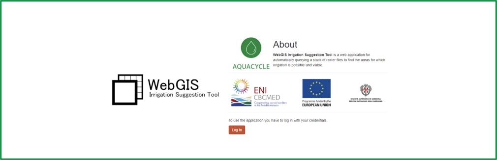
Figure 1: Access page to the online Irrigation Suggestion Tool (http://web-gis-irrigation.iti.gr/)
As shown in Fig. 1, a visitor is informed that the Irrigation Suggestion Tool is a WebGIS application for automatically querying a stack of raster files to find the areas for which irrigation is possible and viable.
Typically, a user will be required to start by uploading a set of maps available for a given area of interest - and this can be any location in the world - that are relevant to the task at hand. All maps are stored in raster format by the WebGIS, i.e. closed polygon shapes are replaced by sets of square pixels.
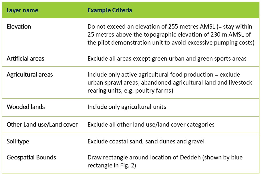
Once the upload is completed, each of the maps can be used to define relevant criteria. A digital elevation model (DEM) can be queried to, for example, retain only areas at a topographic elevation which would not bring about excessive pumping costs, i.e. to retain only areas to which irrigation water could be supplied in an economically viable manner. Once the user has defined criteria for the respective maps, and presses the ‘submit’ button, the WebGIS generates the output in a matter seconds.
By way of illustration, the set of maps uploaded for the Deddeh Koura area in North Lebanon and the criteria applied to each of the maps is shown in Table 1.
Table 1: WebGIS layers and example criteria applied for Deddeh Koura, North Lebanon
Once relevant criteria have been selected and the user has defined the geospatial bounds of the area of interest (shown by the rectangle in blue in Fig. 2), the user is prompted to “submit” the query (rectangular button encircled in green in Fig. 2). Within seconds, the WebGIS displays all the pixels within the area of interest in black colour.
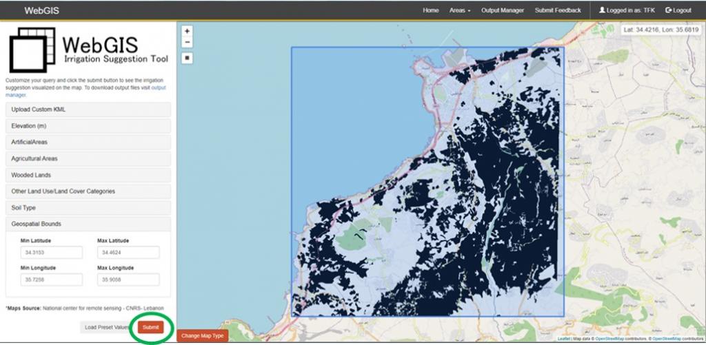
Figure 2: WebGIS displays pixels (in black) that satisfy all the example criteria within the environs of Deddeh Koura, North Lebanon
A further functionality was added to the WebGIS which permits the user to export the raster output into a .kml shape file. This functionality was motivated to enable the AQUACYCLE research teams to import the WebGIS output back onto the PGIS landing pages which had been developed to collect bottom-up inputs towards the drawing up of action plans for the reuse of treated effluent.
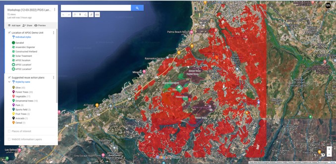
Figure 3: WebGIS output imported onto PGIS Landing page for Deddeh Koura, North Lebanon
In a consequent step, a user can compare the output thus obtained against the existing irrigation areas to find out which of these could be replaced either in part or entirely through the use of treated effluent. Currently irrigated areas in the environs of Deddeh Koura, North Lebanon, are shown in Fig. 4. Evidently, a user may also wish to extend irrigation with treated effluent to areas where this is deemed possible and viable as guided by the WebGIS output.
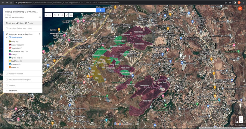
Figure 4: Currently irrigated areas and type of irrigation application in the environs of Deddeh Koura, North Lebanon
The attention of users is drawn to the fact that the output can only be representative of the information that has been uploaded to the WebGIS. As with any decision-support tool, a user is invited to carefully check the degree of accuracy and timeliness of the maps supplied, but should additionally bear in mind that the WebGIS can perform queries only on the basis of the information made available to it.
The WebGIS has been developed and implemented by PhD candidate MSc. Rizos Theodoros Chadoulis, Research Fellow, under the guidance of Dr. Ioannis Manakos, Principal Researcher, who conceptualized, led the design and followed up the realization. Both are employees of the Information Technologies Institute (ITI), Centre for Research and Technology Hellas (CERTH), AQUACYCLE’s Lead Beneficiary.